
A Brief History of Worle
Unless you know better!
Written and now revised by Dave Hart, pictured right.
Written and now revised by Dave Hart, pictured right.
Up to, maybe, 250 years ago, the well documented history of the Weston-super-Mare area should really be called the history of Worle as up
until this time Weston hardly existed. Worle, on the other hand, was the hub of local village life for over a thousand years. It has been suggested that even the name of Weston comes from being a
homestead or tun that is west of Worle. However, once the developers and salesmen got to work on Weston in the early 19th century, Weston was rapidly transformed into a Victorian seaside
health spa, whereas Worle carried on much as it had always done for a further 150 years. Only in the late 1960’s and 1970’s did the developers turn their attention to Worle when most of the building
land in Weston had been used up.
So what did Worle have over the centuries that Weston never did? Did George Bradshaw in his Railway Handbook of 1863 see through Weston’s advertising propaganda when he wrote about Weston having none
of the picturesqueness arising from old streets and buildings, and about the fact the receding tide left a disfiguring bank of mud along the beach which was a great drawback to the enjoyment of
bathing. The best thing about Weston, in his opinion, was the delightful neighbourhood.
Worle Hill is one of the pleasantest spots that a tourist could desire to meet with. In traversing the northern or
sea side of the hill, the path lies most of the way through a copse of young fir trees, presenting occasional openings of the channel and the rocky coast beyond. Towards the eastern end of the hill
beautiful prospects are unfolded over a large and richly cultivated plain, extending to Woodspring priory and Clevedon, with two or three churches standing up above the elms and ashes.
The nearest of these is Kewstoke church, situated on the slope of Worle hill itself. The ruins of the priory of Woodspring are of considerable extent, and very picturesque,
situated in a very solitary position at the farther end of a wide marshy, but cultivated flat: they are divided from the sea by a narrow ridge of rocks, called Swallow Cliffs, quite out of the way of
any frequented road. Crossing the broad mossy top of Worle Hill we can descend upon the village of Worle, which is prettily situated on the southern slope of the hill, and commands a
delightful view over the rich cultivated flat to the range of the Mendip Hills. In short, the inducements to prolong a visit to Weston will be found principally to arise from the
charming localities by which it is surrounded. The climate is bracing and the air very salubrious.
Worle Bury was described in 1791 as an immense rock of limestone-
“ with but very little herbage intermixed; yet here and there a solitary sheep is seen pasturing on its naked, barren ridge, which being elevated far above the surrounding
country, and overlooking the long tract of the Severn Sea, is buffeted by every blast.”
The following are comments about Weston in 1800:
Village Weston could not have had much to offer, while its primitive state charmed some visitors, others wrote complainingly about the cart rutted roads and the stone-riddled tracks that served
as roads and of how when the wind blew they became enveloped in a sandstorm.
“Our friends will recollect the cold, stony hill, without trees or shade of any kind, the unenclosed wastelands, the rugged seaside path, the miserably tortuous roads, the absence of footways,
and the few old dilapidated straggling buildings that made up the then little village.”
The reason nobody lived in Weston was that it was not an easy or pleasant place to live, being exposed to the high tides, storms and regular flooding. The coastal clay belt was generally
flood free, being somewhat higher than much of the low lying areas inland, but the moor was often under water for 4 or 5 months a year.
Nomadic hunter-gatherers of the Middle Stone Age sheltered in a cave at the entrance to what is now Worle quarry, where two Mesolithic flint weapons were found . With the advent of crop
growing and animal husbandry in the New Stone Age the hill became productive farmland and even today Celtic Fields can be detected on the hill in which wheat, oats, barley and beans are known to have
been grown in the Iron Age. The first settlers made for the hillside where the pasture was good, but in the summer months and early autumn they moved their animals down onto the moors,
relatively dry and free from the danger of flooding at that time of year.
The area was always well populated, with at least 20 British Iron Age forts in the area, including Brean, Worlebury, Sand Point, Bleadon, Churchill, Banwell, Dolebury and Cadbury, and with Roman
camps at Brean Down, Uphill, Banwell, Burrington, Blackdown and Charterhouse.
The first visitors to the Worle end of our island in the marsh would have found it to be very hospitable, being mild, south facing and sheltered from the north and west winds. There was fresh
spring water and plenty of wild animals. More importantly, it should have been relatively safe, being isolated by the surrounding marsh, the surging tides and set in a remote part of the
Somerset coast.
The Roman invasion came to England in A.D. 43, and permanent settlement in Worle dates back at least to the Roman Period. Romano British remains have been found near Manorhouse Farm in
Lower Street, at the foot of Spring Hill.
The Romans left in 400AD, and the next 300 years saw a change back to Celtic ways as Roman influence faded.
The Dark Ages were from 400 to 1000 AD. The Saxon kings inherited a Christian Kingdom and hunted on Minndep. Worle was given its name by the Saxons. It may have been Wor-leah
at some time, meaning Wood Grouse Wood.
During Norman times, Walter de Douai took control of Worle from Esgar. There were 50 acres of meadow and enough room for 15 ploughs. Five slaves and 25 labourers worked the manor at
Castle Batch. Piratical heathen Vikings plundered these shores and so ferocious were the attacks that Worle fell in value from £10 in 1066 to £7 in 1086 according to the Domesday Book.
Castle Batch was a 12th Century Medieval manor, a motte and bailey castle, build by the manorial lord who owed allegiance to the Norman overlords. This may have
been Walter de Douai or even William de Courtenai. The Domesday Book gives us a picture of the land use around Worle during that period and for some centuries; pasture on the dry rocky
hilltop; crop-growing in open fields on the fertile soils of the slopes and hay meadows on the wet moors below.
We are reminded of the presence of the Norsemen by the names of the Holms, Wick St Lawrence and perhaps also in that of the little island of Birnbeck.
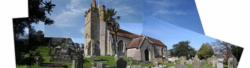
1120: Church of St Martin. The tower has a short spire. Most of the church we see today is of the 15th century. The pulpit was carved from Caen stone
from Normandy and dates from the mid 1550’s. The oldest tomb in the churchyard is inscribed “A Maid in Mold, 60 years old Joane: S.J.A. 1644.”
During the early years of the 13th century there stood in the manor of William de Courtenay at Worspring a chapel dedicated to St Thomas the Martyr and in 1217 William de
Courtenay is recorded as giving the church at Worle to the same monks.
Woodspring Priory had its links with knightly patrons in the Quantock country, and when these patrons visited the priory they would obviously have gone by boat from one of the Bridgwater Bay
ports, round Sand Point, and come ashore to Woodspring at St Thomas’ Head. Here the River Banwell flows into the sea. The flow of the Banwell river is still high today and possibly in
former times it was even greater, so it is reasonable to assume that here was a channel along which boats could also reach Worle and Banwell on a rising tide.
In the 13th & 14th centuries, new rhynes were dug to improve drainage and new and better walls were built along tidal rivers. A bank
called the Wow Wall was built alongside the Grumblepill Rhyne to bar flooding of the fields between the Manor of Banwell on the one side and the Manors of Worle, Hutton, Ashcombe, Weston,
Milton, Uphill, Oldmixon and Locking.
In 1348 the Black Death came to Somerset, the greatest devastation the English population has ever known. During the years 1347 and 1348 the devotion and self-sacrifice of the priesthood
was shown in the record that in those two years Worle had five incumbents. When one, ministering to the sick and dying, was himself struck down, there was another dedicated priest ready to
take over.
Local port records between 1485 and 1518 show a doubling of the small trows and picards carrying fish, grain and other supplies throughout the Bristol Channel. The masters of such craft
often sought unregulated landing places where port duties and custom levies might be avoided. St Thomas’ Head was a regular landing place for 18th century
smugglers. Worle’s vicar was in the know in a smuggling racket which included hiding large kegs of contraband liquor over the north aisle of his church.
The centre of the Worle village was at the top of the Scaurs where it meets Church Road. Here stands the oldest building in Worle apart from the church. Mendip Cottage and The Bell
House were once a single farm house and are of cruck construction, possibly dating from the 14th or 15th century. The village stocks also
stood here. Just across the road in Kewstoke Road is a 16th century cottage called Springwell.
1620: The Lamb Inn is probably the oldest public house in the village still serving its original purpose, although the original Old King’s Head may be even older.
On suppression of Woodspring priory in September 1536, the remaining assets, including land in Worle and Ebdon, and the site of the Manor at Worle were valued at £87. 2s. 11d. A few of
Woodspring’s treasures can be found in local churches, St Martin’s Church at Worle, St Paul’s Kewstoke and at Wick St Lawrence. Towards the end of the 17th century the
priory’s land at Worle was acquired by the Pigott family.
Manorhouse Farm in Lower Street dates from the 17th century, as does Rock Cottage and The Roundhouse in Lawrence Road (a former toll house), Wrides Cottage and probably
the Old Forge in Kewstoke Road, and the block of cottages and the bakery surrounding The Valiant Soldier (1670) in Church Road. Magnolia Cottage in Ebdon Road has a wing dated to the
17th century suggesting that the main house may be even older.
1685: Worle received some notoriety for harbouring rebels on the run after Monmouth’s ill-fated rebellion. John Starr, the landlord of the Old King’s Head is said to have been
approached by one of the rebels who was on the run from the soldiers, and asked if he might hide on the premises of the inn. This was agreed, and then John Starr reported him to the soldiers
who had him hung, drawn and quartered, and his head displayed on St Martin’s Church. Did Judge Jefferies stay at the Valiant Soldier in Church Road en route to Taunton for the trials of the
rebels?
Extensive mining took place on Worle Hill, firstly for lead ore, and then during the C16, C17, C18 and early C19 for calamine. In 1565 there was the record that the calamine discovered was
far better quality than that unearthed in Germany and that an Englishman and his German partner took a lease of Sir Henry Wallope of a hill in Somersetshire called Worle Hill. Although this
was mostly effected above the general level of cultivation, it did spread further down the hillside in the area of Hawthorn Hill and Hawthorne Combe. They were still in operation in 1829.
An old mine shaft was found when a service trench was dug in the road near the Old King’s Head.
The importance of Worle as a local centre is well known. In the 18th century, the local woollen industry expanded to include a trade in cotton and people would have
come from all over the area to buy materials. As Weston started to grow, Worle became village Weston’s shopping centre and the local commercial centre for the outlying villages, containing a
General Supply Store at the top of the Scaurs and other essential trades. At one time Weston’s postal address was “near Worle”.
1726: Manchester House, on the corner of Lower Kewstoke Road and Church Road, was built. It was later known as Worle Supply Stores, Stall Corner and then Spinners Stores [1897]
before becoming Gunnings Stores when Ivy Spinner married Henry Gunning. Tower View at the top of the Scaurs is also 18th century. Facing Manchester Square is Maywood House, a late
18th century building. The intersecting roads in this area enclose a space that was once used for playing bowls and may once have been the village green.
The area became known locally as Manchester Square.
1765: Worle Mill (which closed 1870)
Main roads were unknown until the 18th century. By 1792, we can find Bristol Road, Spring Hill, Church Street, Lawrence Lane, The Scores, Hollow Lane, Ebdon
Road and Kewstoke Road. Lower Street leads eastwards to St Georges and Banwell . All the country lanes as we know them today are there: Lyfield Road, Dunkite Lane,The Newtons, Ebdon
Road, Brimbleworth Lane, Summer Lane and the roads to Wick St Lawrence and Bourton. There are no roads across Worle moor, Locking moor or Hutton moor, and no roads in the Bridgwater direction.
There was no bridge across the River Axe until 1808.
1795: James May & Thomas Castle opened the Worle Brewery on the corner of Moor Lane and Lower Street. An anchor was found ten feet below the surface when the foundations were being
prepared for the brewery, suggesting that there may have been access to the sea from this area along Madam Rhyne. A lease of 1682 referred to “all the profits etc of tolls for the landing of
cattle etc at Anchor Head, Dropping Well and Hill End of Worle Hill.” The brewery ceased trading in 1868.
In the 19th century, there were still no established roads, just the important bridges. Walking your animals to Bristol market would have been an epic journey for
farmers in the Worle area. The roads around Worle, before the Congresbury Drainage Act of 1819 and the straightening of the Yeo at Congresbury, were just a series of local tracks subject to
frequent inundation. Visitors to Worle had to travel via Banwell and then to Locking Head and across a low ridge to Worle. The journey from Worle to Weston involved the steep climb up
the Scaurs, and then along the hill into Weston. The last coach to use this route was in 1832.
1801: The Lord of the Manor of Worle was Edward Ash Esquire.
1802: Worle Quarry was started. It was included in an early excursion guide for geologists in 1912 as it displayed strata of carboniferous limestone that had been fractured by a
fault and turned upside down by the earth movements that formed the Mendips 290 million years. The fault can be traced through the length of the hill to Birnbeck.
1803: Enclosure of Worle and Tickenham. Parliamentary enclosure was becoming common among north Somerset parishes by the end of the 18th century, the motive
generally being a desire for greater agricultural efficiency on the part of leading landowners. It ended the commoner’s rights over open land. Some plots were sold off to pay for the
process, which would have included new roads, hedges, ditches and walls.
1806: Regular carrier service from Worle to Weston by Messrs. Stabbins and Hill but it was short lived. As well as passengers, goods had to be taken to Weston to supply staying
visitors and guests. Weston had no shop, the nearest being at Worle. This was the retail centre for all the local villages. Beer for the Weston hotel had to be brought to Weston
by handcart from the Worle Brewery.
1809: The enclosure of Congresbury, Wick St Lawrence and Puxton created a possible road to Worle across the moor.
1810: Weston Act of Enclosure
1811: John Harse revived the carrier service with success.
1813: Vale Mill (It closed in 1910). Two more carriers were now operating from Worle to Weston.
1814: A limited coach service was started between Bristol and Weston via Worle and Congresbury. Outside Gunning’s Store, in Manchester Square, is where you would have caught the
stage coach.
1815: The New Inn opened. Its public rooms were the largest in the area and were often used for auctions.
1818: Post-chaise hiring advertised in the area by John Harse.
1819: Congresbury Drainage Act – major improvements to improve drainage south of the Yeo.
Circa 1820: Madam Lane and Rickett’s Lane
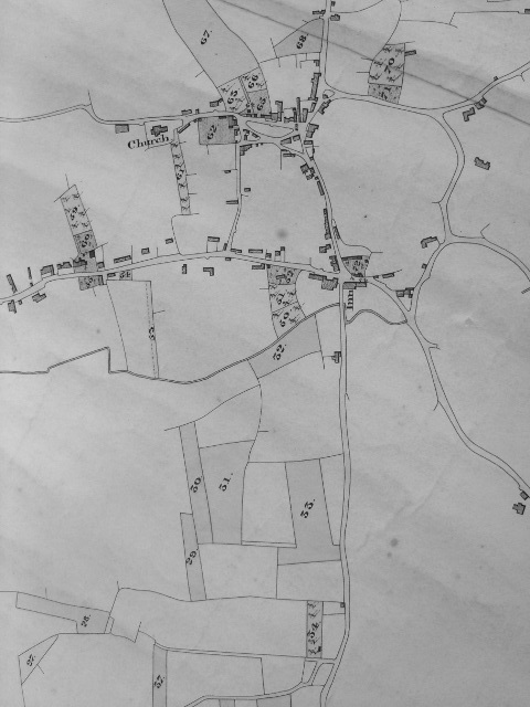
The map of 1831 shows Ivy Lodge, Nutwell Farm, The Rows (also known as the three Tenements or The Square), Fairfield, Prospect Cottage, The Golden Lion, the
Vicarage, Neathway’s bakery, Greenwood Cottages and the Brewery in Lower Street, Craigside, Maywood, the School and Under Church Cottages in Church Road, White House Farm in Moor Lane, and Myrtle
Cottage (now The Croft) in Lawrence Road. Nut Tree Farm, Court Farm and Magnolia Cottage in Ebdon Road are also on the map. Magnolia Cottage is the only thatched cottage in Worle.
Sunnybank and Rosebank cottages in Lawrence Road are said to be C18 but are not on this map or the 1885 map.
Most of Lower Road is a creation of the 19th century. In earlier centuries summer grazing on the lower land was possible but building would have been futile. Worle
Hill was essentially an island and the surrounding marsh in bad weather was indistinguishable from the sea. High Street building only became feasible once the low lying land of Worle Moor had
been drained.
1837: Ebenezer Chapel in Lawrence Road.
1839: Turnpike road proposed from Lower Street (now High Street) to Watersill Road (now Locking Road) to eliminate difficult gradients. A Trust was formed 1840 and the road was built
in 1841 by Doggett & Manning.
1841: The Great Western Railway passed by Worle, staying well away on the moor because the Pigotts didn’t want the railway on their land. The nearest station was called Banwell Road,
but was changed to Worle in 1861.
A letter in 1856 stated: “I have been induced to make some inquiries respecting this rural and pleasant village and find it much improved. – The land is in a high state of
cultivation, especially the arable; the houses are much improved and in good order; the gardens are kept with that neatness and care that makes them good to look upon; they have an
extensive and thriving brewery, two large general shops, and several smaller ones, good butchers, bakers and other useful houses of business; they are well supplied with the means of grace, having a
church and three chapels.”
By 1860, Moor Lane, Locking Moor Road, Hutton Moor Road and Drove Road had appeared showing that the moor was being successfully drained.
Market gardening on the slopes of Worle hill increased in the late 19th century as Weston expanded and its population needed to be fed. C & J Greenwood
commented in 1822 that the population of Worle had increased considerably in consequence of the demand for poultry and other articles for the supply of the adjoining parish of Weston.
1865: Hillside School, built on the site of the tithe barn.
1866: The Golden Lion Inn opened.
1878: Ebenezer Chapel Schoolroom extension, between the Chapel and the cottage.
1879: The Weston-super-Mare Sanitary Laundry opened in Station Road in the old brewery premises. It stayed in business for about one hundred years. The south-facing hill was a
good drying area for washerwomen who journeyed in and out of Weston weekly, some with donkey drawn carts, to collect the weekly wash from the hillside gentry’s large establishments, returning with
their carts piled high with the washing wrapped in knotted sheets looking like loads of huge white pumpkins.
1884: The Weston Loop line was built and Worle had its own station accessed from Moor Lane. The first Worle station was renamed Puxton.
A map of 1885 now shows Coal Bridge, Preans Green House, Westonia Cottage, Cherry Tree Farm and an enlarged brewery in Lower Street, and Hillside and Sunnyside
houses in Church Road, and Springfield House in Spring Hill.
The village’s first row of shops is The Parade.
1890: Capital and County Bank opened on the corner of Mendip Avenue and High Street.
1892: Captain Batiscombe and his wife lived at “Hillside” in Church Road.
1898: Weston, Clevedon & Portishead Railway built through Worle. When it opened the station was known as Worle. This was Worle’s third station. It changed to Worle (Moor
Lane) in 1913, and in 1917 it changed its name again to Worle Town. It closed in 1941.
1902: Coronation Road, named after the Coronation of Edward VII. During the time it was under construction, it was known as Ten Acre Road having been built in The Ten Acres
field.
1903: Two ladies from Ferndale, South Wales, on the Ferndale Band outing, killed by train on the High Street crossing while on a wagonette excursion returning via Worle to Weston-super-Mare.
The wagonette was owned by Mr Guppy of Regent Street.
1904: Miss Violet Hardwick laid the foundation stone for the Village Club in Mendip Avenue.
1904 – 1912: Greenwood Road
1905: Springfield House is now the home of the Hardwick’s.
1918: Milton Road Extension built, linking the lower end of Baytree Road in Milton to Lower Street.
1922: Worle’s Memorial Clock Tower.
1919: Skidmore and Sons was opened.
1922: Worle’s second station was closed. Puxton Station is renamed “Puxton and Worle”.
1923: New Bristol Road was built by-passing Worle’s Lower Street, which included the building of the Grumblepill and Madam Rhyne culverts.
Circa 1928: Lower Street renamed High Street.
1930’s: The 3 Tenements demolished and TheRows built, with the garden fronting High Street.
1940: Worle Secondary School, Spring Hill
1939 – 1945 War: Bomb damage in various parts of Worle including Westonia Cottage, opposite the Golden Lion in High Street, where three members of the Jones family died on
3rd September 1940.
Until the 1960’s, very little had changed in Worle, but then the development of land for housing and business started and has continued ever since.
1960?: Court Farm / Madam Lane bungalows
1963: Manorhouse Farm Estate on Church Road and The Weind. Housing on Hawthorn Hill
1968: Rhynedale Estate on Mendip Avenue. Mendip Green school.
Circa 1965: Nutwell Rd & Ryecroft Avenue.
The explosion of building came in the 1970’s.
Council development on Prean’s Green & Tavistock Road
1968 - 1973: M5 Motorway and Junction 21.
1964: Puxton and Worle Station closed.
1966 to 1970: Pilgrims Way and Tormynton Road
1969 – 76: Worle Hill market gardens built over, creating Balmoral Way, Wigmore Gardens, Pleshey Close, etc.
1971: Worle Comprehensive School opened.
Early 1970’s: Mead Vale (“Bird land”).
North Worle Retail Centre (Sainsburys)
Mid 1970’s: Verbena Way and houses to the east of Moor Lane (“Plant Land”), largely completed by 1980.
1981: St Marks Church, signifying that the development of the Queensway, Beckett, St marks Rd and Wandsborough Roads were well underway.
1990: Worle’s fourth station, Worle Parkway opened.
1994: A370 Dual Carriageway and access roads to Worle.
2003- 2006?: Locking Castle, Wick St Lawrence, St Georges, Weston Village.
2007 to 2012: Developments at West Wick and along Wolvershill Road.
2013 – 2014: Road improvements to Junction 21, extra car parking at Worle Parkway Station, and Weston Gateway developments by Junction 21 including The Hungry Horse.
With most of Worle’s land now used up, the developer’s attentions have switched to the Weston airport site, but the wettest spring on record has highlighted the need to maintain and improve the
local drainage system for, without it, Worle Moor will soon return to being a marsh!
Most of the houses of old Worle survive, far more than detailed here. The footpaths that once took people to church, or from the outlying villages to Worle, or to work at the mill, the
quarry or the brewery, are still here too. These were the paths that were short-cuts across arable or common land, or land that was unsuitable for carts. All the old lanes are here.
Rather than being obliterated by modern development, the houses, lanes and footpaths have actually shaped it. The byways, Dunkite Lane, Madam Lane, Ricketts Lane, Moor Lane, Mead Lane and
Brimbleworth Lane are still here and relatively untouched, if smothered, neglected and ignored. St Marks Road and Cherrywood Road now follow the farm access tracks that were in those
areas. Many more paths have been added for our enjoyment, including the beautiful River Banwell path from St Georges to Ebdon Bow. There are still large areas of open spaces to replace the
farmer’s fields that have been lost to housing; Castle Batch, Lynch Farm, Plumley Park and all the park land off Walford Avenue. Beyond the River Banwell, down quiet lanes, on field paths, in
the small villages, and on the river banks, is still the Northmarsh, as wonderful as it always was, virtually untouched and waiting to be explored.
The rural beauty of Worle Hill also survives. Follow the hillside paths from Hillend, Pilgrim’s Way, Hawthorn Combe, Pleshey Close or Helen’s Steps and you enter a sheltered world of
meadows and hedges, woodland and scrub that seems virtually unchanged since the miners left it two centuries ago. Golfers may have replaced the animals that grazed on the common land on the
brow of the hill, but the view is much the same as in Bradshaw’s day. The ruins of the Woodspring Priory are very picturesque, situated in a very solitary position at the farther end of a wide
marshy, but cultivated landscape, separated from the sea by Middle Hope and well away from any busy roads. And in the other direction there is the delightful view over the rich cultivated
lands to the Mendip Hills.
In short, the inducements to prolong a visit to Weston will be found principally to arise from a visit to the charming locality of Worle and its surroundings. Long may it remain
so.
Revised & updated 11AUG14.